Published 08:16 IST, June 11th 2019
CYCLONE VAYU Latest: IMD issues warning, storm likely to partially hit Mumbai, maintains bearing for Gujarat's Saurashtra
As parts of the country brace for the monsoon to make its full impact, the Indian Meteorological Department (IMD) has once again issued a cyclone warning for 'Cyclone Vayu' off India's west coast, forecasting an increase in the speed of the winds, increased rainfall and rise in the height of the tides.

As parts of the country brace for the monsoon to make its full impact, the Indian Meteorological Department (IMD) has once again issued a cyclone warning for 'Cyclone Vayu' off India's west coast, forecasting an increase in the speed of the winds, increased rainfall and rise in the height of the tides.
Latest position and bearing:
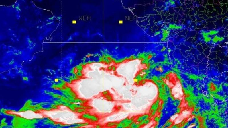
As of early morning on Tuesday, Cyclone Vayu was about 540 km south-southwest of Mumbai, moving northwards and intensifying.
As per the IMD, Mumbai is not likely to bear the full brunt of the cyclone as it is expected to cross about 250-300 km away, parallel to the Mumbai coast early morning on Wednesday. A cyclone warning has nonetheless been issued for fishermen and people living near the coastline.
Porbandar and Devbhoomi Dwarka are expected to be the worst affected as per the Cyclone's current bearing, with authorities in Navsari, Porbandar and Dwarka likely to start proactive evacuation before the projected landfall on June 13. As per inputs, emergency camps and control rooms are being set up in the Saurashtra region to tackle the situation.
(IMD image at 7:30 am on Tuesday)
The IMD, on Monday night, had issued a warning to the fishermen along the coast of the Arabian Sea and the Bay of Bengal, asking them to not 'venture into the rough seas' and advised those in the deep sea to return:
"The cyclonic storm ‘Vayu' , which is brewing over East-central & adjoining Southeast Arabian Sea, has moved north-northwestwards with a speed of about 11 km per hour in the last six hours and lay centered near latitude 14.2°N and longitude 70.6°E over East-central & adjoining Southeast Arabian Sea, about 410 km north-northwest of Aminidivi (Lakshadweep), 600 km south-southwest of Mumbai (Maharashtra) and 740 km nearly south of Veraval (Gujarat)," the IMD has said in its earlier bulletin after announcing that it had escalated from a deep depression into a cyclonic storm.
Skymet, a weather company, also predicted the cyclonic storm to hit parts of the coastal regions.
Places in Kerala, coastal and South interior Karnataka, Konkan, and Goa region, South Gujarat region, Saurashtra and Kutch and Lakshadweep are forecast to receive moderate to heavy rainfall beginning from 11 June and continuing for three days till 14 June. The wind speed is likely to rise up to 115 km per hour post which it would return to the current speed of 50-70 km per hour. The gusty winds are expected to bring heavy showers along the coasts of Maharashtra and Gujarat.
Updated 10:47 IST, June 11th 2019


