Published 20:15 IST, January 27th 2021
Robert Vadra misrepresents India's map by leaving out Kashmir; BJP leaders hit back
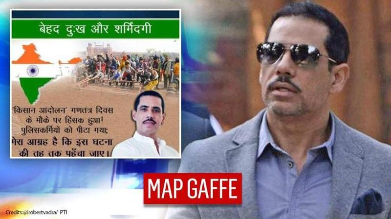
In a big gaffe on Wednesday, Congress general secretary Priyanka Gandhi Vadra's husband Robert Vadra posted an image that featured India's map without Kashmir.

In a big gaffe on Wednesday, Congress general secretary Priyanka Gandhi Vadra's husband Robert Vadra posted an image that featured India's map without Kashmir. In the aforesaid image posted on his Twitter account, the businessman stated that it was a matter of shame that the farmer's agitation had turned violent on Republic Day. Taking into account the fact that many police personnel sustained injuries, he opined that it was necessary to go to the root of the matter. Vadra's act of depicting a wrong map of India comes at a time when Congress leaders such as P Chidambaram have backed the restoration of Jammu and Kashmir's special status. Reacting to this development, Delhi BJP general secretary Kuldeep Singh Chahal and Majura MLA Harsh Sanghavi contended that Vadra had given away Kashmir to Pakistan.
Here is the image posted by Vadra:
Misrepresentation of India's map
Incidentally, this is not the first time when the Indian map has been distorted. A few weeks ago, BBC World Service stirred controversy when a graphic on its broadcast 'US Election 2020: What do countries around the world want from Joe Biden' depicted India without Jammu and Kashmir. This elicited a strong response from Labour Party MP Virendra Sharma who termed the action as "deeply insulting" in a letter addressed to BBC Director-General Tim Davie. Asserting that J&K is an integral part of India, he called upon the BBC to not only withdraw the graphic but also demanded action to ensure that this doesn't repeat again. Subsequently, the BBC apologised and updated the map of India reflecting the boundaries of J&K.
Similarly, Twitter had to apologise for showing a part of J&K as Chinese territory. This controversy came to the fore on October 18, 2020, when national security analyst Nitin Gokhale noticed that his location (near Leh airport) was displaying 'Jammu and Kashmir, the People's Republic of China' on Twitter. Moreover, the Parliamentary Joint Committee on the Personal Data Protection Bill, 2019 expressed strong displeasure over the geotagging issue and asked Twitter to submit a written apology and an affidavit. Besides this, the Ministry of Electronics and Information Technology wrote to Twitter CEO Jack Dorsey reminding him that Leh is the headquarter of Ladakh and that both Ladakh and J&K are 'integral and inalienable parts of India, governed by the Constitution of India'.
Updated 20:15 IST, January 27th 2021


