Published 14:03 IST, November 6th 2021
NASA shares 1st images captured by Landsat 9, providing critical data on Earth from space
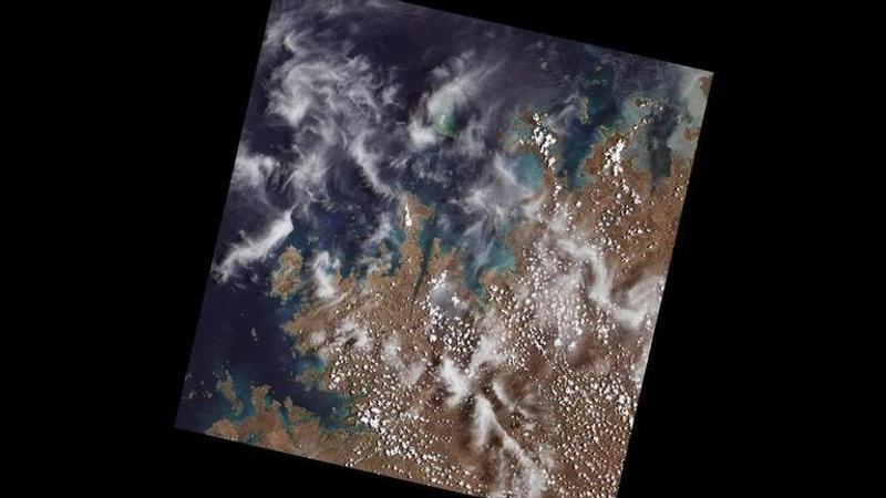
NASA: The images were acquired on October 31 under a joint mission between NASA and the US Geological Survey (USGS) and were captured by Landsat 9.

Taking to the microblogging platform, the National Aeronautics and Space Administration (NASA) has shared the first light images of Earth. The images were acquired on October 31 under a joint mission between NASA and the US Geological Survey (USGS) and were captured by Landsat 9. According to a press release by NASA, these images would provide a deep insight into how the mission will help people manage vital natural resources and understand the impacts of climate change.
NASA Administrator Bill Nelson said, "Landsat 9's first images capture critical observations about our changing planet and will advance this joint mission of NASA and the U.S. Geological Survey that provides critical data about Earth's landscapes and coastlines seen from space. This program has the proven power to not only improve lives but also save lives. NASA will continue to work with the USGS to strengthen and improve accessibility to Landsat data so decision-makers in America—and around the world—better understand the devastation of the climate crisis, manage agricultural practices, preserve precious resources, and respond more effectively to natural disasters."
These images were captured by Landsat 9 in Detroit, Michigan, with neighbouring Lake St Clair, cities adjoining beaches along a changing Florida coastline, and images from Navajo Country in Arizona. These images will add to the existing data and will provide vital information to closely examine crop health and manage water irrigation. Moreover, it will also provide data about the changing landscapes of the Himalayas in High Mountain Asia and the coastal islands and shorelines of Northern Australia, said the press release.
Landsat 9, which was launched on September 27, 2021, is similar in design to Landsat 8, which was launched back in 2013 and remains in orbit. Landsat 9 helps in transmitting data with a higher radiometric resolution of Earth, featuring subtle differences over darker areas including dense forests and water bodies. The new satellite can easily differentiate over 16,000 shades of a given wavelength colour, while the satellite being replaced detects only 256 shades. The increased sensitivity in Landsat 9 will help users to see more subtle changes which were not possible before. NASA's Landsat 9 project scientist, Jeff Masek, who operates at Goddard Space Flight Center, said, "First light is a big milestone for Landsat users-it's the first chance to really see the kind of quality that Landsat 9 provides. And they look fantastic. When we have Landsat 9 operating in coordination with Landsat 8, it's going to be this wealth of data, allowing us to monitor changes to our home planet every eight days."
NASA's Landsat Programme
The advanced Landsat 9 has the ability to capture two images, including the Operational Land Imager 2 (OLI-2) and the Thermal Infrared Sensor 2 (TIRS-2). It can detect near-infrared and shortwave-infrared light in nine wavelengths and thermal radiation in two wavelengths to measure Earth's surface temperatures and their changes. "The data and images from Landsat 9 are expanding our capability to see how Earth has changed over decades. In a changing climate, continuous and free access to Landsat data, and the other data in NASA's Earth-observing fleet, help data users, including city planners, farmers, and scientists, plan for the future, "said Karen St. Germain, Earth Science Division director at NASA Headquarters in Washington. According to the press release, NASA's Landsat 9 team is conducting a 100-day check-out period. Landsat 9 and Landsat 8 will operate jointly to collect nearly 1500 images of Earth's surface every day, covering the globe every eight days.
(With inputs from ANI)
(Image: Twitter/@NASAEarth)
Updated 14:03 IST, November 6th 2021


