Published 19:21 IST, July 13th 2020
Volcanic Island in Japan captured by NASA space satellites as it continues to spew lava
NASA's Satellites capture a breathtaking picture of the remote island of Nishinoshima in the Pacific Ocean as it is spewing lava and ash. Know more

Nishinoshima is a volcanic island located almost 600 miles or 1,000 kilometres south of Tokyo in Japan. In the past few years, volcanic activity on Nishinoshima has picked up the pace. Most recently, two NASA satellites have captured breathtaking aerial views of the Volcanic Island, thus tracking the Lava’s growth over the past few months. The NASA satellites have also observed that the Volcanic Island of Nishinoshima is experiencing a growth spurt following the recent years of volcanic activity.
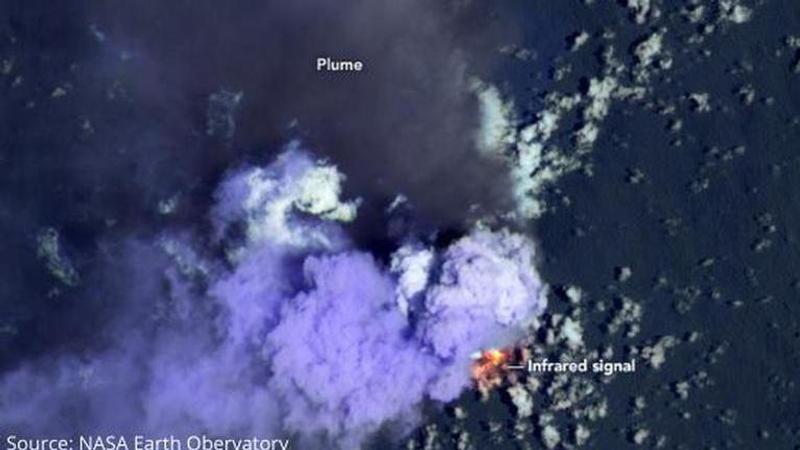
Picture of the Volcanic Island of Nishinoshima captured by NASA
With the joint effort of the American Space Agency NASA and the United States Geological Survey, the Landsat 8 satellite has captured a striking snap of the island on Sunday, July 4, 2020. As per the reports of a space portal, NASA and US Geological survey did this by combining shortwave infrared lights and visible wavelengths. The shortwave infrared lights include between 1,100 and 3,000 nanometers.
Source: NASA Earth Observatory (July 6, 2020)
In the process, they were able to reveal a heat signature showing the lava erupting from the Volcanic Island. The relative coolness of the dark ashes also plumed as they were blowing north across the Pacific Ocean. As per the reports of a science portal, in a statement issued by a scientist, they have claimed that in the NASA satellites’ image one can also see bright purple clouds representing steam coming out of the volcano or the lava from vaporising the seawater.
Source: NASA Earth Observatory (July 4,2020)
The Volcanic Island, Nishinoshima
According to the reports of a media portal, on July 3, 2020, the Japan Coast Guard had reported massive volcanic plumes which rose as high as 15,400 feet or 4,700 meters, above sea level. It was also reported that the plumes had grown drastically in size by the next day. A science portal had reported that from July 4, volcanic bombs or larger fragments of solid and molten material were spewing out up to 1.6 miles or 2.5 km.
As per reports by a science portal, even the clouds of ash reached up to 27,200 feet or 8,300 meters in height which is the highest altitude recorded since the volcano first emerged in 2013. The Volcanic Island Nishinoshima had erupted above sea level in November 2013, generating active lava flows which remained active as late as November 2015. According to the reports of a media portal, frequent volcanic activity has fuelled the growth of the island.
In 2020, the Volcanic activity on Nishinoshima island had commenced in late May 2020, but the growth became vigorous by mid-June. A science portal has revealed that reports from Japan’s Geospatial Information Authority suggest that the southern shore of the island grew by at least 492 feet or 150 meters within a span of 13 to 14 days between June 19 and July 3. Information about the growth of Nishinoshima and about the evolution of the island's volcanic activity is available online at NASA Earth Observatory. Satellite images dating back to 2013 are also available.
Source: NASA Earth Observatory (2017)
Updated 19:21 IST, July 13th 2020


