Published 12:43 IST, May 7th 2020
'Looks like a checkerboard': NASA satellite images show grid pattern in Japan’s Hokkaido
NASA Satellite images of a landscape in eastern Hokkaido province of Japan show an interesting grid pattern that looks like checkerboard.

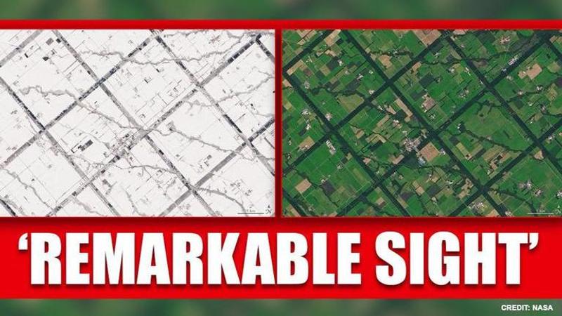
Japan's Hokkaido island "looks remarkable" with its 'grid pattern' from the sky as revealed by the images captured by NASA. Satellite images of a landscape in eastern Hokkaido show an interesting grid pattern that looks like a checkerboard. NASA revealed in a press release that the pattern is clear year-round -- even under a blanket of snow.
NASA Earth Observatory shared natural-colour images of the Konsen Plateau taken by the Operational Land Imager on the Landsat 8 satellite. The first image, taken on September 27, 2019, shows a massive grid pattern. The pattern in dark green can be seen across the rural landscape.
(Photo: Landsat 8/NASA Earth Observatory)
The second image was taken on Feb. 27, 2020 and one can see the grid pattern clearly even when the province is covered by a thick layer of snow.
(Photo: Landsat 8/NASA Earth Observatory)
According to NASA, "The strips are forested windbreaks—180-meter (590-foot) wide rows of coniferous trees that help shelter grasslands and animals from Hokkaido’s sometimes harsh weather. In addition to blocking winds and blowing snow during frigid, foggy winters, they help prevent winds from scattering soil and manure during the warmer months in this major dairy farming region of Japan. The thinner, less regular strips are forested areas along streams."
The agency further explained that the grid pattern is inspired by land development and farming practices popular at the time in pioneer areas of the midwestern and central United States. It further noted that the Japanese government began creating the windbreaks in the 1890's. Back then, the purpose of these windbreaks was to colonize the area and instead of planting forested strips, they simply cleared squares into the broadleaf forests.
"Over time, as bits of windbreaks were cleared for timber or by wildfires, the broadleaf forests were replaced by plantings of larch and spruce that make up most of the windbreaks today," the agency added.
Purpose of windbreaks
The windbreaks are primarily used to slow down the speed of the wind which in turn benefits the crops, livestock and even people. Typically, windbreaks are created by planting trees and shrubs in the area. However, in case of Hokkaido, the government opted to just clear out squares from already existing forests instead of planting forest strips.
Apart from slowing down the wind, these windbreaks often also serve several other purposes as they can be used to reduce the noise, odor and visual impact from livestock operations. In some places, they can also provide an additional source of income if the trees in the windbreak can produce fruits, nuts or even materials for crafts.
Updated 12:44 IST, May 7th 2020


