Published 10:18 IST, July 8th 2022
US: Storm Derecho turns South Dakota sky to ominous green; here's why it happened
A series of derecho storms tore through several parts of the US on Tuesday, rolling down trees, snapping power lines, and swooshing through fields. Read more

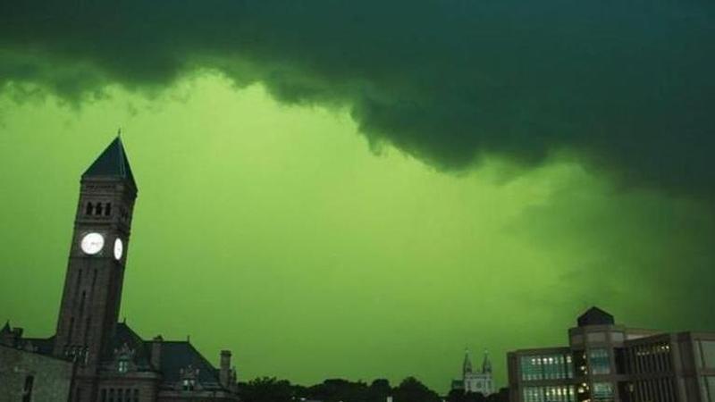
A series of tropical storms tore through several parts of the US on Tuesday, rolling down trees, snapping power lines and swooshing through fields. Before the wind gusted at around 140 km/hour, the citizens of South Dakota witnessed a startling rare phenomenon as the skies over the midwestern US turned ominous, bright green. The thunderstorm, which meteorologists said qualifies as a derecho, picked up speed, leading most avid storm chasers to wonder about the usual yet remarkable sight they witnessed.
Now, before diving into what caused the rare atmospheric optics, it is pervasive to understand what is a derecho.
The term derecho comes from the Spanish phrase "la Derecha", which translates as 'straight' in English. According to the US National Weather Service, a derecho is a long-lived, widespread, straight-lines storm and generally has no twists and turns like tornados or hurricanes. It is listed under the "band of rapidly moving showers or thunderstorms" mostly transpiring during summertime beginning in June & July. They are rare occurrences, unlike other tropical storms that have previously ripped through the US. According to the University of Oklahoma, to be classified as a derecho, a storm must have a gust speed of 93 km, with evident impact on over 400 km of land area and the gap between successive winds must not be over 3 hours.
There are usually three types of Derechos - progressive, serial, and hybrid.
Eerie green light ahead of derecho storm
Netizens and storm chasers were equally inquisitive about the eerie green light that lit US cities ahead of the storm. The Washington Post theorized that the luminescent bright green was a result of the reflection of blue wavelengths of the storm that penetrated below the cloud and reflected on the water droplets, which, when struck against the red-yellow of the afternoon and produced a green colour. The colour is also dependent on the water vapor content in the atmosphere ahead of the storm.
The storm on Tuesday unleashed in the city of Sioux Falls, South Dakota. The resplendent leafy green colour captured by nature-lovers drew netizens' attention, who compared it with "something straight out of" Netflix's popular sci-fi series Stranger Things. Two pictures were wildly viral, one that showed a turret clock at half-past three and another one captured dramatic tidal wave-like clouds lined in with blue daylight glow peaking from in between.
Is this phenomenon common?
The atmosphere turning goblin green colour is not a natural visual. Green skies ahead of a storm usually indicate strong hail, says the National Weather Service. "It is the tremendous amount of water vapour content within the could...which usually means the presence of a substantial amount of ice (large hail)," NWS meteorologist Dr. Cory Martin explained to WP.
Derechos are common across the central and eastern US. The most intense derecho recorded in all times was that of May 8 which destroyed land and lives from Kansas to Kentucky. The wind speed was reportedly 170km/hr. Outside the US, such a straight-moving gale has been observed in Russia, and European countries like Germany, Finland, and Bulgaria.
(Image: @Jaden/Twitter)
Updated 10:18 IST, July 8th 2022


